Indiana County Highlights
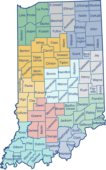
The County Highlights profile provides a snapshot of critical population and workforce statistics for each of Indiana's 92 counties.
Select a county on the map below to view profile

These data are updated throughout the year, not just on an annual basis. They are available in an easy-to-use web format but are also printable.
What You Will Find
Click any county on the map to access data on:
- Population
- Education
- Commuting
- Labor force
- Industry
- Income
- Firm size
Contact your regional analyst
Don’t hesitate to contact your local analyst if you need additional information on your area.
-
Region 1
Jasper, Lake, LaPorte, Newton, Porter, Pulaski, and Starke -
Region 2
Elkhart, Fulton, Kosciusko, Marshall, and St. Joseph -
Region 3
Adams, Allen, DeKalb, Grant, Huntington, LaGrange, Noble, Steuben, Wabash, Wells, and Whitley -
Region 4
Benton, Carroll, Cass, Clinton, Fountain, Howard, Miami, Montgomery, Tippecanoe, Tipton, Warren, and White -
Region 5
Boone, Hamilton, Hancock, Hendricks, Johnson, Madison, Marion, Morgan, and Shelby -
Region 6
Blackford, Delaware, Fayette, Henry, Jay, Randolph, Rush, Union, and Wayne
-
Region 7
Clay, Parke, Putnam, Sullivan, Vermillion, and Vigo -
Region 8
Brown, Daviess, Greene, Lawrence, Martin, Monroe, Orange, and Owen -
Region 9
Bartholomew, Dearborn, Decatur, Franklin, Jackson, Jefferson, Jennings, Ohio, Ripley, and Switzerland -
Region 10
Clark, Crawford, Floyd, Harrison, Scott, and Washington -
Region 11
Dubois, Gibson, Knox, Perry, Pike, Posey, Spencer, Vanderburgh, and Warrick
 Hoosiers by the Numbers